
Lipari. Acropolis. Prehistoric villages
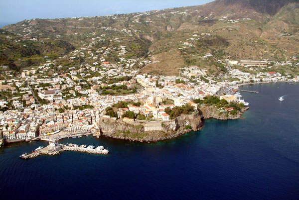 Lipari. The Castello seen from the sea
The Acropolis of ancient Lipàra geologically consists of a mass of rhyolite (fine-grained igneous rock), in part vitreous, which rises from the coastal plain of Diana and projects with precipitous rock walls into the sea, forming two little bays, two natural harbours: Marina Lunga to the North, Marina Corta to the South. The excavations conducted by Bernabò Brea and Madeleine Cavalier from 1950 onwards then uncovered on the upper plateau of the Castello the traces of the Greek and Roman city and the prehistoric villages that preceded them, revealing a stratification that reached a depth of nine metres at some points. The Cnidian colonists founded the new Lipàra here in the 50th Olympiads (580-576 BC). The area of the Acropolis must soon have proved to be insufficient, however, and so the city spread over its slopes down to the plain below. The Greek city was destroyed by the Romans in 252-251 BC. The Romans then transformed the acropolis into a fortress, probably razing all its buildings to the ground. This explains the almost total absence of buildings of the Greek period. Only a century later, once the political situation in the lower Tyrrhenian had changed and the Aeolian Isles had lost all their strategic value, the acropolis once again returned to be a residential quarter. Dating to this period is a town plan consisting of a series of rectangular blocks (insulae), divided by seven rectilinear streets (cardines), equidistant and running parallel to each other from East to West; each of them is 10 feet wide and furnished with an axial drainage channel. These streets were intersected orthogonally by a series of other wider streets (decumani) running from North to South. As far as the earlier periods are concerned, the building remains attributable to Ausonio II and Ausonio I (late Bronze Age) in the southern zone of the archaeological area are limited. By contrast, there are conspicuous remains of the village of the Milazzese period (middle Bronze Age) superimposed over the village of Capo Graziano (early Bronze Age). In the northern zone the huts of the Milazzese and Capo Graziano periods are equally numerous but less conspicuous, in part because overlaid by the huts of Ausonio I and Ausonio II. The archaeological deposit descends for a further four or five metres below the floor level of the huts of the early Bronze Age. The stratigraphy was explored by trial shafts, later filled in, sunk within the individual huts and with larger trial trenches opened to the West.
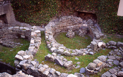 The Castello of Lipari. Detail of the huts of the middle Bronze Age superimposed over those of the early Bronze Age
Bibliography:
- L. Bernabò Brea M. Cavalier F. Villard, Meligunìs Lipàra, vol. IX. Topografia di Lipari in età greca e romana. Parte I. L'Acropoli. Palermo 1998, pp. 1-265.
- L. Bernabò Brea M. Cavalier, Il Castello di Lipari e il Museo Archeologico Eoliano, Flaccovio, Palermo 1970, pp. 1-214.
- L. Bernabò Brea M. Cavalier, Meligunìs Lipàra IV. L'Acropoli di Lipari nella preistoria con appendici di W. Taylour, M. Garasanin, E. Contu, J.L. Williams, M. Alessio, F, Bella, C. Cortesi, B. Turi, T. Mannoni, Palermo 1979, (volume di testo) pp. 1-875 ; (volume di tavole) tavv. I-CCCXXII e l'atlante.